![](/images/other/stat-length.png)
![Randonnée V.T.T. Les Allues - Col de la Lune depuis Le Villard - Photo](https://media.geolcdn.com/t/1900/400/ext.pjpeg?maxdim=2&url=https%3A%2F%2Fstatic1.geolcdn.com%2Fsiteimages%2Fupload%2Ffiles%2F1524743154velo.jpg)
Col de la Lune depuis Le Villard
tracegps
Utilisateur
![Longueur](/images/other/stat-length.png)
![Altitude max](https://static1.geolcdn.com/siteimages/upload/files/1508320355ic_sort_altitude_max_24dp.png)
![Dénivelé positif](https://static1.geolcdn.com/siteimages/upload/files/1508320355ic_sort_den_pos_24dp.png)
![Km-Effort](/images/other/stat-length.png)
![Altitude min](https://static1.geolcdn.com/siteimages/upload/files/1508320355ic_sort_altitude_min_24dp.png)
![Dénivelé négatif](https://static1.geolcdn.com/siteimages/upload/files/1508320355ic_sort_den_neg_24dp.png)
![Boucle](https://static1.geolcdn.com/siteimages/upload/files/16400158638029165_repeat_loop_refresh_sync_direction_icon.png)
![V.T.T.](https://static1.geolcdn.com/sitytour/trail-icons/202.png)
4h00
Difficulté : Difficile
![Scannez ce code QR pour ouvrir la randonnée dans l'application SityTrail](https://capi.geolives.com/qq0zvz2zws4bq2lad0pu/sitytour/trails/103017/qr.png?size=200)
Application GPS de randonnée GRATUITE
À propos
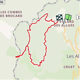
Randonnée V.T.T. de 10,2 km à découvrir à Auvergne-Rhône-Alpes, Savoie, Les Allues. Cette randonnée est proposée par tracegps.
Description
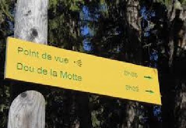
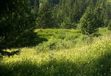
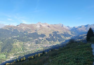
Circuit de 600m de dénivellé permettant d'atteindre le Col de la Lune (1820m) à partir du Villard, village perché au dessus des Allues dans la Vallée de Méribel. La montée s'effectue en forêt sur une piste jeepable, jusqu'au hameau de La Traie. Après quelques minutes encore de marche, vous arrivez au plateau du Plan des Danses. La Col de la Lune se trouve à 10 minutes à peine de marche. Du Col de la Lune, il est possible de poursuivre en direction du Col de Leschaux puis éventuellement vers la Croix Jean-Claude en passant par le Dos de Crêt Voland. Compter 1h de plus de montée. Pour le retour, plutôt que de refaire le parcours inverse, un joli sentier en forêt doit être trouvé au niveau du Plan des Danses. Puis retour au Villard par une piste forestière.
Localisation
Commentaires
Randonnées à proximité
![Randonnée Marche Les Belleville - Tour de Creve Tete - Photo](https://media.geolcdn.com/t/375/260/775f7fbd-61fe-4dac-aa88-5ad251aeb72f.jpg&format=jpg&maxdim=2)
![Marche Marche](https://static1.geolcdn.com/sitytour/trail-icons/101.png)
Marche
![](/images/other/stat-length.png)
![](https://static1.geolcdn.com/siteimages/upload/files/16400158638029165_repeat_loop_refresh_sync_direction_icon.png)
![Randonnée Marche Feissons-sur-Salins - Rando à Feissons - Photo](https://media.geolcdn.com/t/375/260/063eb2f4-6bf4-4b4a-a131-fc9697177278.jpg&format=jpg&maxdim=2)
![Marche Marche](https://static1.geolcdn.com/sitytour/trail-icons/101.png)
Marche
![](/images/other/stat-length.png)
![](https://static1.geolcdn.com/siteimages/upload/files/16400158638029165_repeat_loop_refresh_sync_direction_icon.png)
![Randonnée Marche Feissons-sur-Salins - Croix de Feissons - Photo](https://media.geolcdn.com/t/375/260/ext.jpg?maxdim=2&url=https%3A%2F%2Fservices.sitytrail.com%2FGeolivesWS%2FDownloadMedia.ashx%3FTrailID%3D958597%26Media%3D3ded4b2c-a6b8-4dd9-b494-9ab426781ec1.jpg)
![Marche Marche](https://static1.geolcdn.com/sitytour/trail-icons/101.png)
Marche
![](/images/other/stat-length.png)
![](https://static1.geolcdn.com/siteimages/upload/files/16400158638029165_repeat_loop_refresh_sync_direction_icon.png)
![Randonnée Marche Brides-les-Bains - Brides les Bains - Photo](https://media.geolcdn.com/t/375/260/d966be4d-7a5e-462b-885b-72f95b4b7992.jpg&format=jpg&maxdim=2)
![Marche Marche](https://static1.geolcdn.com/sitytour/trail-icons/101.png)
Marche
![](/images/other/stat-length.png)
![](https://static1.geolcdn.com/siteimages/upload/files/16400158638029165_repeat_loop_refresh_sync_direction_icon.png)
![Randonnée Marche Feissons-sur-Salins - Feissons sur salins / Bois du sapey - Photo](https://media.geolcdn.com/t/375/260/372d571c-3325-4051-9cd3-72995a78efc6.jpg&format=jpg&maxdim=2)
![Marche Marche](https://static1.geolcdn.com/sitytour/trail-icons/101.png)
Marche
![](/images/other/stat-length.png)
![](https://static1.geolcdn.com/siteimages/upload/files/16400158638029165_repeat_loop_refresh_sync_direction_icon.png)
![A pied A pied](https://static1.geolcdn.com/sitytour/trail-icons/100.png)
A pied
![](/images/other/stat-length.png)
![](https://static1.geolcdn.com/siteimages/upload/files/16400158638029165_repeat_loop_refresh_sync_direction_icon.png)
![Randonnée Marche Les Belleville - Beranger La croix de Jean Les refuges Le col de la lune - Photo](https://media.geolcdn.com/t/375/260/c5ad1e17-310b-48d4-b0e4-7e1619b4b8e6.jpg&format=jpg&maxdim=2)
![Marche Marche](https://static1.geolcdn.com/sitytour/trail-icons/101.png)
Marche
![](/images/other/stat-length.png)
![](https://static1.geolcdn.com/siteimages/upload/files/16400158638029165_repeat_loop_refresh_sync_direction_icon.png)
![Randonnée Marche Les Allues - les Allues à Combe Cure - Photo](https://media.geolcdn.com/t/375/260/ext.jpg?maxdim=2&url=https%3A%2F%2Fservices.sitytrail.com%2FGeolivesWS%2FDownloadMedia.ashx%3FTrailID%3D596392%26Media%3Dfix__20160711110233.jpg)
![Marche Marche](https://static1.geolcdn.com/sitytour/trail-icons/101.png)
Marche
![](/images/other/stat-length.png)
![](https://static1.geolcdn.com/siteimages/upload/files/16400158638029165_repeat_loop_refresh_sync_direction_icon.png)
![Randonnée Moto Les Belleville - rando menuires - Photo](https://media.geolcdn.com/t/375/260/6a459a38-d7c5-4ace-8cc3-add6d0d07428.jpg&format=jpg&maxdim=2)
![Moto Moto](https://static1.geolcdn.com/sitytour/trail-icons/402.png)
Moto
![](/images/other/stat-length.png)
![](https://static1.geolcdn.com/siteimages/upload/files/16400158638029165_repeat_loop_refresh_sync_direction_icon.png)
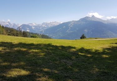
Très jolie balade surtout quand on arrive au com de la lune oú la vue sur la vallée de Belleville est magnifique.